- YourGovernment
-
OurCommunity
-
- About Tualatin Advisory Committees Animal Services Community Involvement City Codes City Council City Projects
- Community Crime Reports Customer Service Request Explore Tualatin Now Fire Library Municipal Court Tualatin Today
- Parks & Recreation Passports Permits & Forms Planning & Zoning Police Volunteer Tualatin Moving Forward
-
-
ForVisitors
-
- Parks, Greenways, Recreation and Library Library Parks Public Art Parks and Recreation
- Shopping, Dining, and Entertainment Chamber of Commerce
- Community Events Community Theatre Pumpkin Regatta Special Events
-
- DoingBusiness
-
HowDo I?
-
- Apply for a Job Apply for an Advisory Committee Contact the City Council Get a Copy of a Police Report File a Records Request Find Forms
- Find Planning & Zoning Find Public Transportation Find the City Code Get a Business License Get Email Subscriptions/Notifications Locate City Offices
- Contact the City Pay My Traffic Fine Pay My Water Bill Reserve a Facility Sign Up for a Recreation Program Search the Website Volunteer
-
Planning Ahead for High Water on the Streets

As the weather turns to winter and occasions of heavy rain, at the City we plan for impacts to our transportation system. There are certain areas in town which are prone to temporary localized flooding.
What to Expect During a Heavy Rain Event at Martinazzi Ave. & Tualatin-Sherwood Road
- High water signs will be posted at the start of the event
- If the water is 6” to 8” high at the outside curb, right lanes will be closed and all traffic diverted into the inside lane
- If the water is 6” to 8” high at the inside curb, the road will be closed to cars and small trucks. Large trucks will be allowed to proceed through the high water at a slow speed
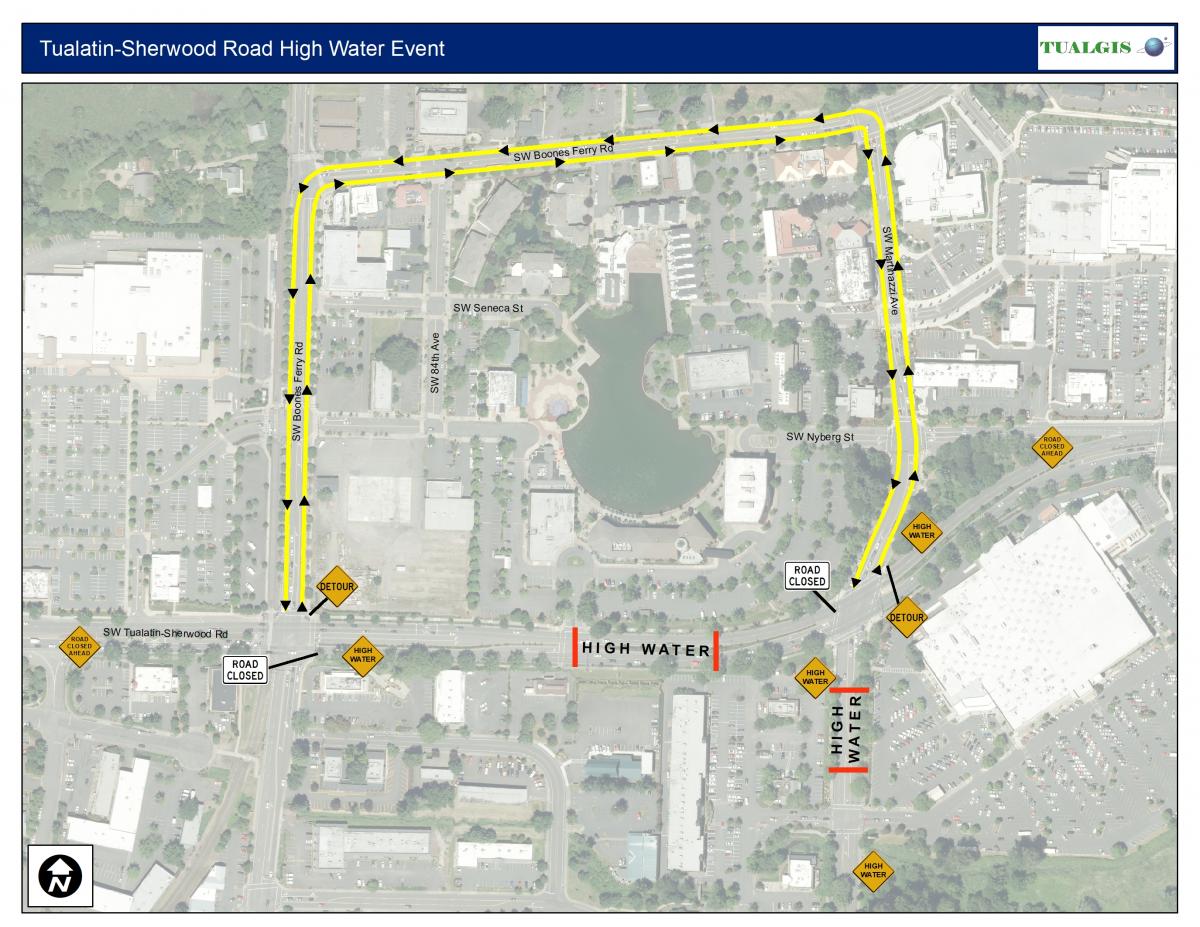
- A detour route will be put in place (see the map attached below for higher resolution)
If high water signs are place on any roadway, please remember: slow down, drive slowly, and if you feel uncomfortable about driving through high water please do not.
Never drive around "Road Closed" signs posted on the road. Always follow instructions from flaggers.
Below is a map of the typical detour map we will use to ensure safety during localized flooding on Tualatin-Sherwood Road and Martinazzi Avenue.
If you have questions, please contact Street/Sewer/Storm Division Manager Bert Olheiser at 503-691-3096 or contact our Public Works front desk at 503-691-3091.
